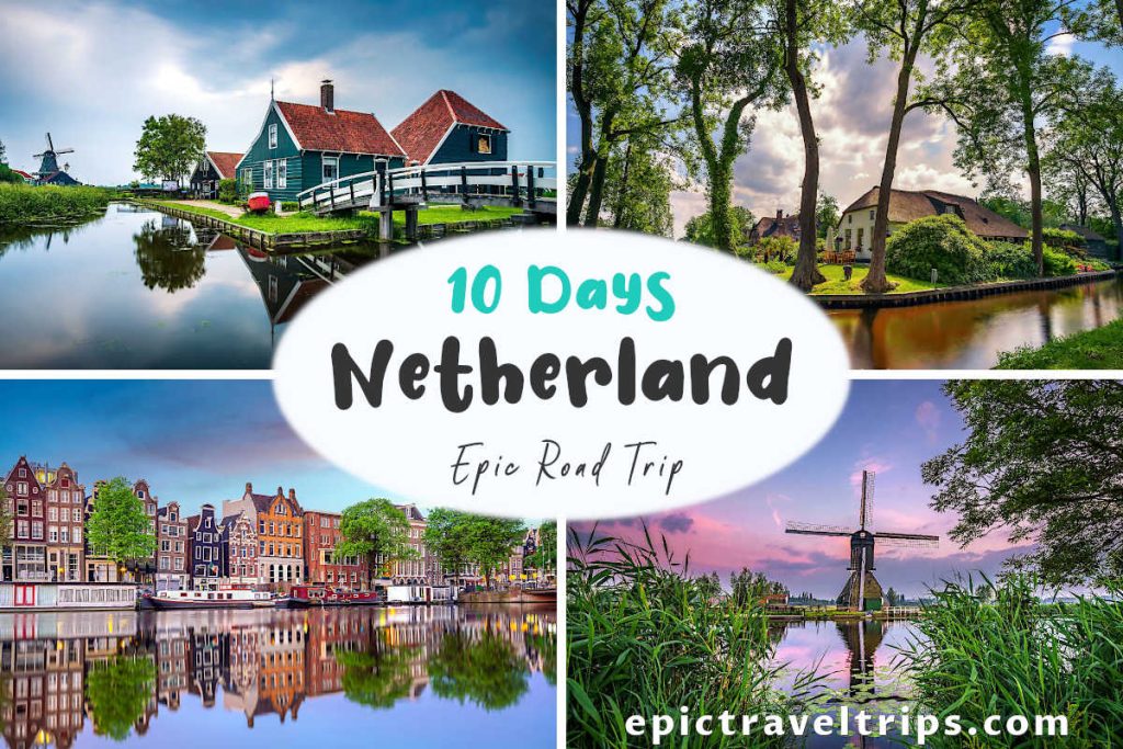

- What is?
- Things To Do
- Where is located?
- How To Reach?
- How Long Does It Take?
- Where To Park?
- When Is The Best Time To Visit?
- What Is Nearby?
- Fort Bourtange – Our Impressions
What is Fort Bourtange?
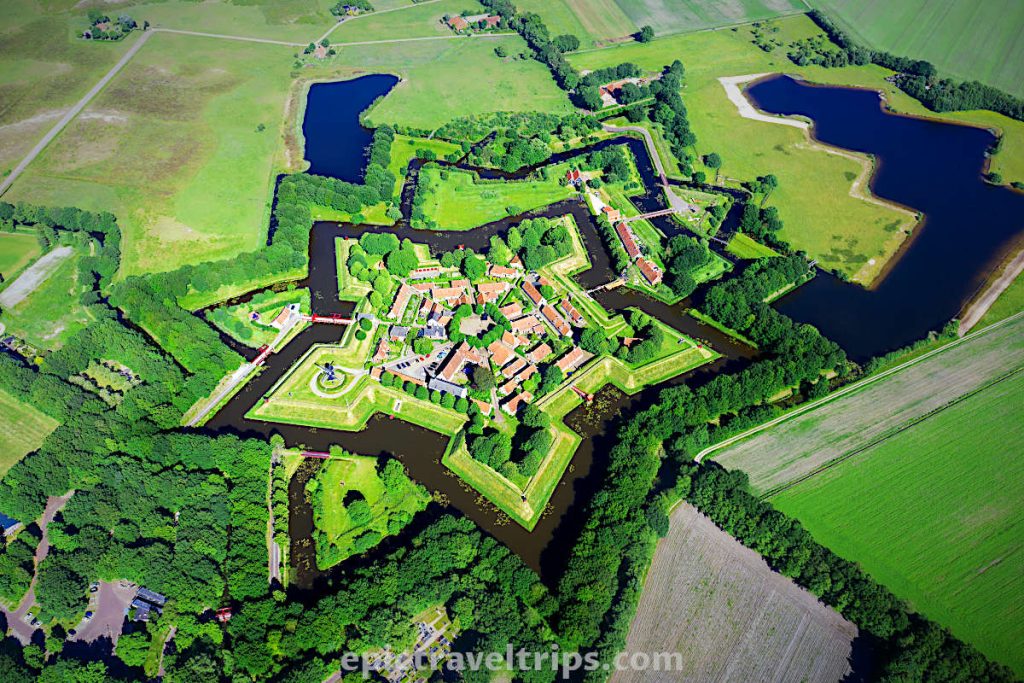
Fort Bourtange (Vesting Bourtange in Dutch) has the specific shape of a pentagon. Each of the five bastions (peaks) is the shape of a spearhead. As with any other fortification, it was designed and built for the defense of the territory.
There are several rings of ramparts and moats around the fort. Their construction was due to the need for extra protection. These obstacles slowed down the attackers’ advance during sieges.
We saw a similar fortress at Fredrikstad in Norway. It is one hour’s drive from our home. Fredrikstad is a lot bigger and has the shape of a half-star. The reason is one side has natural obstacles by the sea and river.
We noticed similarities in many words between the Dutch and Norwegian languages. So we will point out them throughout our articles as exotic facts.

We could not understand why this particular spot the builders chose. It is not on a hill to watch the area. It is not on some important cross-road or near a river. Finally, any potential invaders can bypass the fort with ease. To get that answer, we need to go back to the past when Dutch ancestors did not master the drainage of wetlands yet.
Fort Bourtange – History
Let’s turn the time clock back to the year 1580. It was the year when Prince William of Orange gave the order to build the fort. The trading route between Groningen and Westphalia region in Germany passed through this area. It was a marsh area with a few hard sandy passes four centuries ago. So Boutrange was one of the existential passages through this harsh terrain at the time.
Here are historical facts about Fort Bourtange:
- 1580 – Prince William of Orange gave the order to build an entrenchment with five bastions on the sand ridge,
- 1593 – the entrenchment was completed,
- 159x – fort siege in the Eighty Years’ War by the Spaniards,
- 1672 – fort siege in the Franco-Dutch War,
- 1737-42 – fort further expansion and strengthening of defensible condition,
- 1851 – military fort was officially dismantled and turned into an agricultural village,
- 1960 – the restoration of the fort to its 1742 condition and conversion to a historical museum,
- 2001 – a soldier’s barracks and the former coach house were completed and used as hotel accommodations.
Not only the terrain was different at the time. Look at the map of Europe today and notice where Spain is now compared with the XVI and XVII century.

Fort Bourtange – Design
The whole fort design is for its military purpose. The defenders would deploy the cannons along the fort’s edges. Due to the bastion’s spearhead shape, such deployment was very effective. Cannons were the formidable weapon of choice at that time. This cannon layout allowed better defense with fire coverage and cross-fire points. Square or rectangular fort shapes would leave certain areas defenseless.
Heckman Bastion shows us the cannons’ layout and how this looked in the past.
The musket gun range dictated the distance between bastion tips. If one bastion was under massive attack, muskets from neighboring bastions defended it.
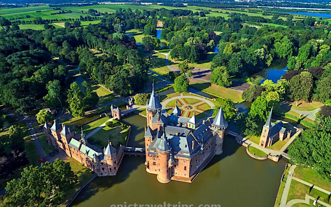
We visited De Haar Castle (Kastel De Haar) on The Netherlands: Epic 10 Days for Perfect Itinerary Road Trip with Maps. So we had a chance to notice the mentioned differences.
Fort Bourtange – What To See
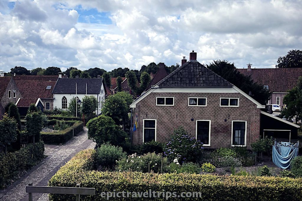
We crossed the border between Germany and the Netherlands while we drove to the fort. The road is a typical narrow flat country road between rows of trees. We passed by many red brick houses with grass yards without fences. Finally, we reached the village and parked in front of the information center.
We walked through the information center to get some basic info about the fort and what the area offers.
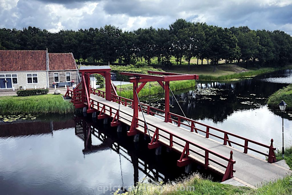
As we exited the information center, we crossed a small red bridge. Next, the cobblestone path, shared by pedestrians and cyclists alike, leads us to the fort. Before we entered the fort, we crossed a couple of more prominent red bridges to enter it. Inside we walked straight to the Market Square. Many cyclists took a break in the nearby café-restaurants enjoying the morning coffee or tea.
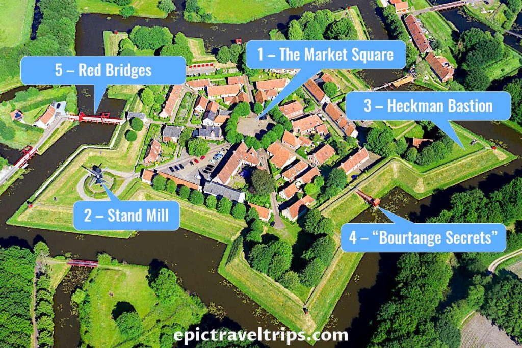
1 – The Market Square
The Market Square is in the middle of the fort, and all streets lead to it like sun rays. We noticed 16 lime trees surrounded the square. We already had breakfast and morning coffee. So we skipped the restaurants and headed to the Stand Windmill.
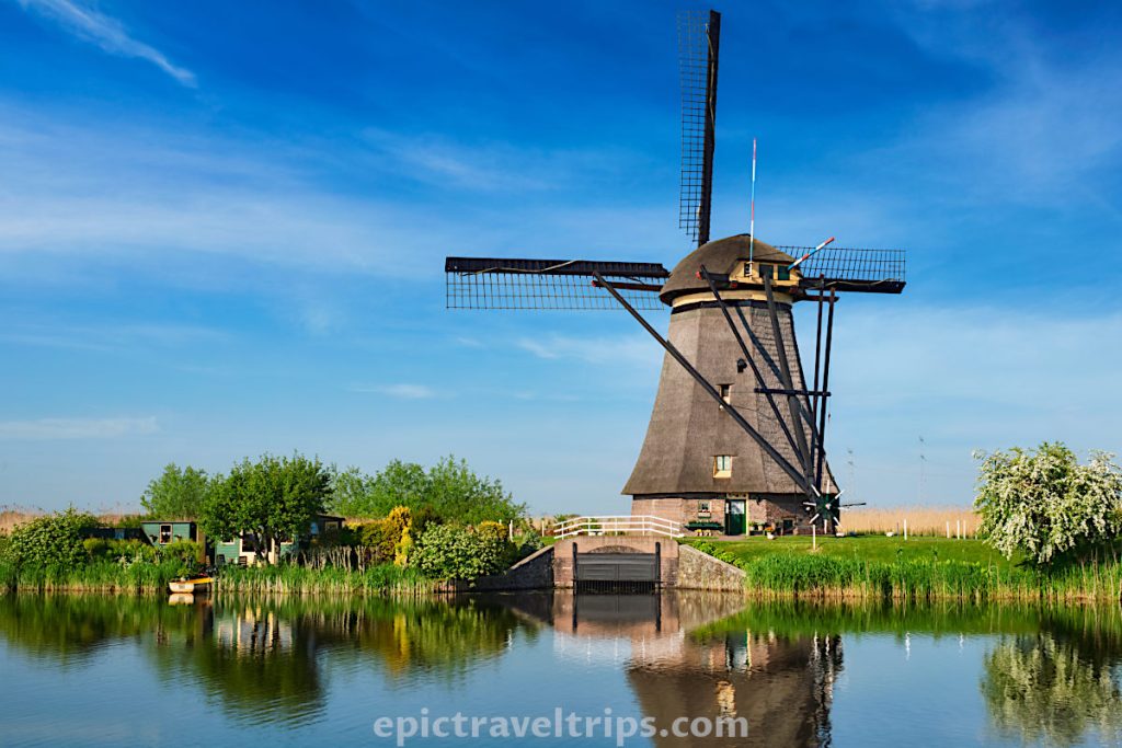
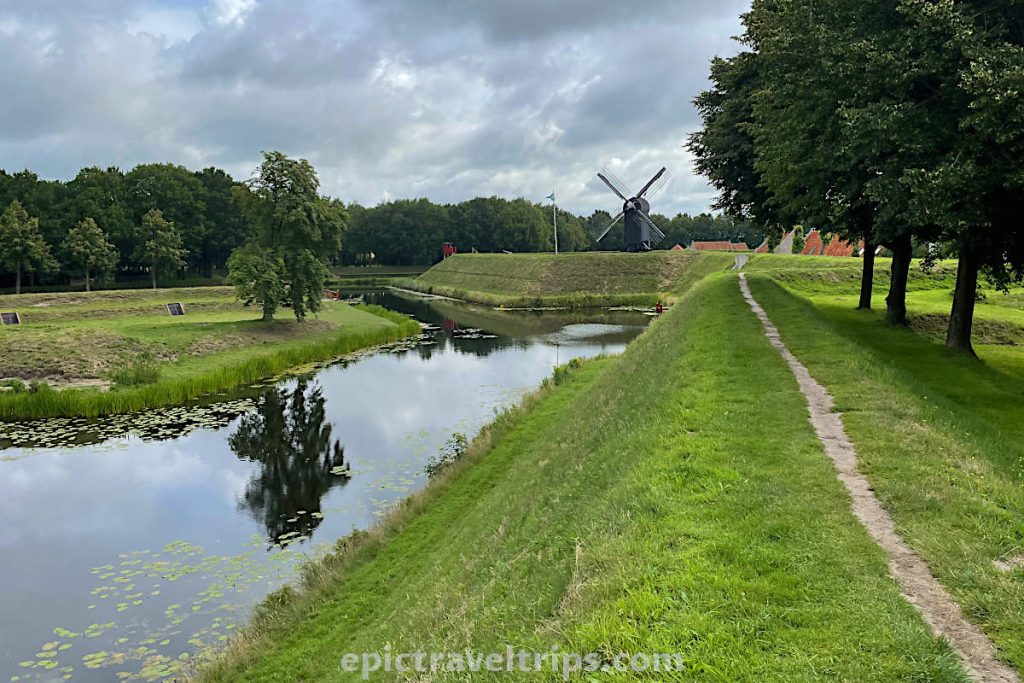
2 – Stand Mill (Vestingmolen Bourtange)
The black wooden Stand Windmill lays at the rampart in the middle of one of the five spearhead shapes (bastions). But, this is a 1980s replica that stood once here and provided the corn and bulling mill. It was a most striking sight in the fortress, at least for us. Please notice that the miller stopped the sails at 45 degrees angle and formed an X cross (also known as Andrews cross). It means that the windmill has a long rest.

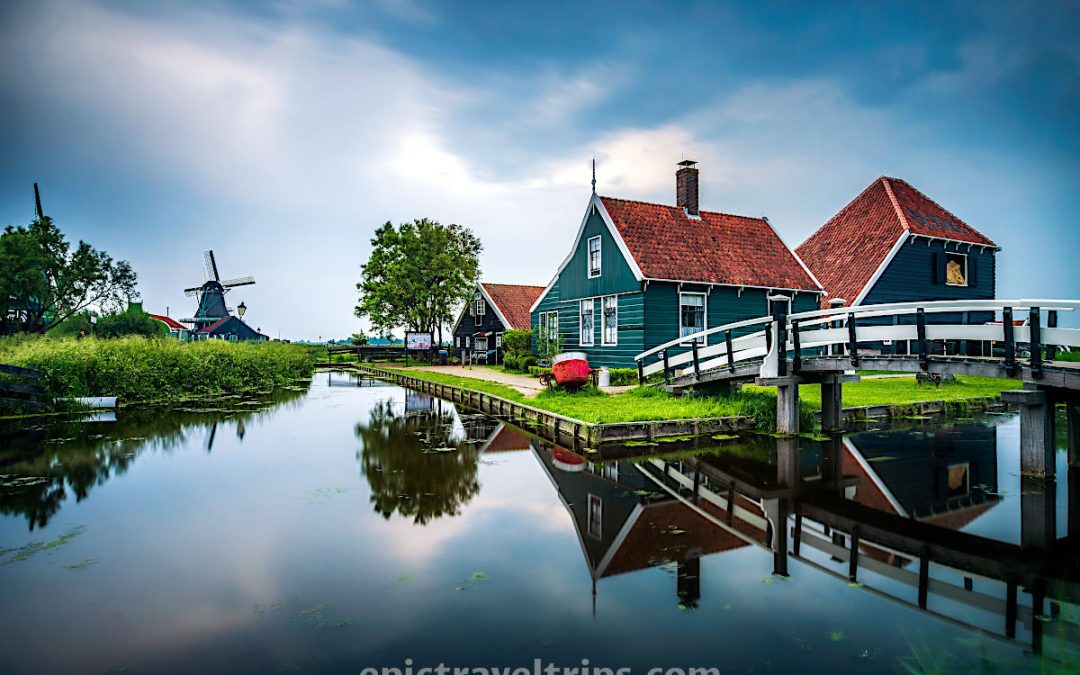
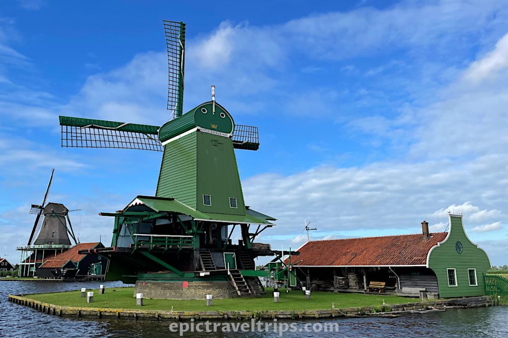
Yet, the most impressive windmills in Holland are Zaanse Schans Windmills and Kinderdijk Polder Windmills.
Zaanse Schans is like an old industrial park where each windmill is an individual factory.
At Kinderdijk is a different story. The windmills here are polder drainage windmills. They are part of the water management system. Since one-third of The Netherlands is below sea level.
Let’s come back to the fort walk. We walked rampart around the fortress to the Heckman Bastion. It is cannons emplacement on the opposite side from the mill.
3 – Heckman Bastion
Several cannons deployed show us what the fort defense looked like. It is time for a quick photo session.

We passed by the biggest surprise of the fort visit, “Bourtange Secrets”.
4 – “Bourtange Secrets”
“Bourtange Secrets” are historical toilets used by the soldiers. There are three of them, and they are wooden buildings that stand above the water. I bet soldiers used them extensively when attackers wanted to cross over the moat and conquer the fort.
5 – Red Bridges
On our way back, we climbed up the rampart once again. So we can take one more look at the red bridges and moats that provide entrance and exit from/to the fort.
6 – The Museums
There are various museums and exhibitions in the fort. The information center sells museum tickets. The Museum De Baracquen shows us what solder life looked like in one of the barracks. Captain’s house gave better accommodation facilities for the high-rank officers. Synagog was a house of prayer for the Jewish community that lived in the fort and converted into a museum.
Where is Fort Bourtange Located?
Fort Bourtange is in the northeast Netherlands in the Groningen region, a few kilometers from the German border. To be more precise, in Westerwolde municipality (South-East Groningen).
Groningen is the closest bigger city and northeast of the fort 50 minutes drive and 62 km (38.5 mi).
We made a Google map of our The Netherlands: Epic 10 Days for Perfect Itinerary Road Trip with Maps and would like to share it with you.
How To Reach Fort Bourtange?
The most convenient way is by car.
By car: We drove from Germany since we had an overnight stay in the village just across the border.
Here are a few driving times:
- Amsterdam – Fort Bourtange is 2h 40 min drive, 240 km (149 mi)
- Groningen – Fort Bourtange is 50 min drive, 62 km (38.5 mi)
- Bremen (Germany) – Fort Bourtange is 1h 30 min drive, 125 km (78 mi)
- Rotterdam – Fort Bourtange is 3h drive, 275 km (170 mi)
By train: Fort Bourtange is not on the national rail network.
If you click this link and make a purchase, we earn a commission at no additional cost to you.
However, it is possible to take the train from Groningen to Winschoten, then switch to bus 14 (direction Stadskanaal via Vlagtwedde) to Vlagtwedde, switch again to bus 72 (direction to Ter Apel) to Bourtange village, and walk the last 800 m (10 min).
If you travel from Amsterdam then take the train to Groningen and from there follow the instructions from the previous paragraph.
By bus: There is a local bus 72 between Vlagtwedde and Ter Apel that passes by Bourtange village.
How Long Does It Take Fort Bourtange Visit?
Two to three hours are enough to walk around, take photos and enjoy the scenery. We visited the fortress in the morning, and there weren’t many visitors. So our tour was not overcrowded.

Where To Park For Fort Bourtange Visit?
Parking is in front of the information center. There are plenty of parking spaces and even a few for the buses.
You can leave your four-wheel “friend” in the shades of trees to sleep and wait for new on-road adventures. At the same time, you will enjoy your fortress tour.
When Is The Best Time To Visit Fort Bourtange?
We visited Fort Bourtange in July during our summer vacation. The fortress is open all year round. The spring and summer months between April and September are most attractive for a visit.
Fort Bourtange – Events
There is a demonstration of cannon shooting Every Sunday at 3 pm during the season (April to September). It will bring you back to the old days of the XVII century.
At the beginning of June, there is an annual event for reconstructing battles from the past called “The Battle for Bourtange”.
What Is Nearby Fort Bourtange?
Fort Bourtange is on the German-Dutch border and the first place we visited on our The Netherlands: Epic 10 Days for Perfect Itinerary Road Trip with Maps.
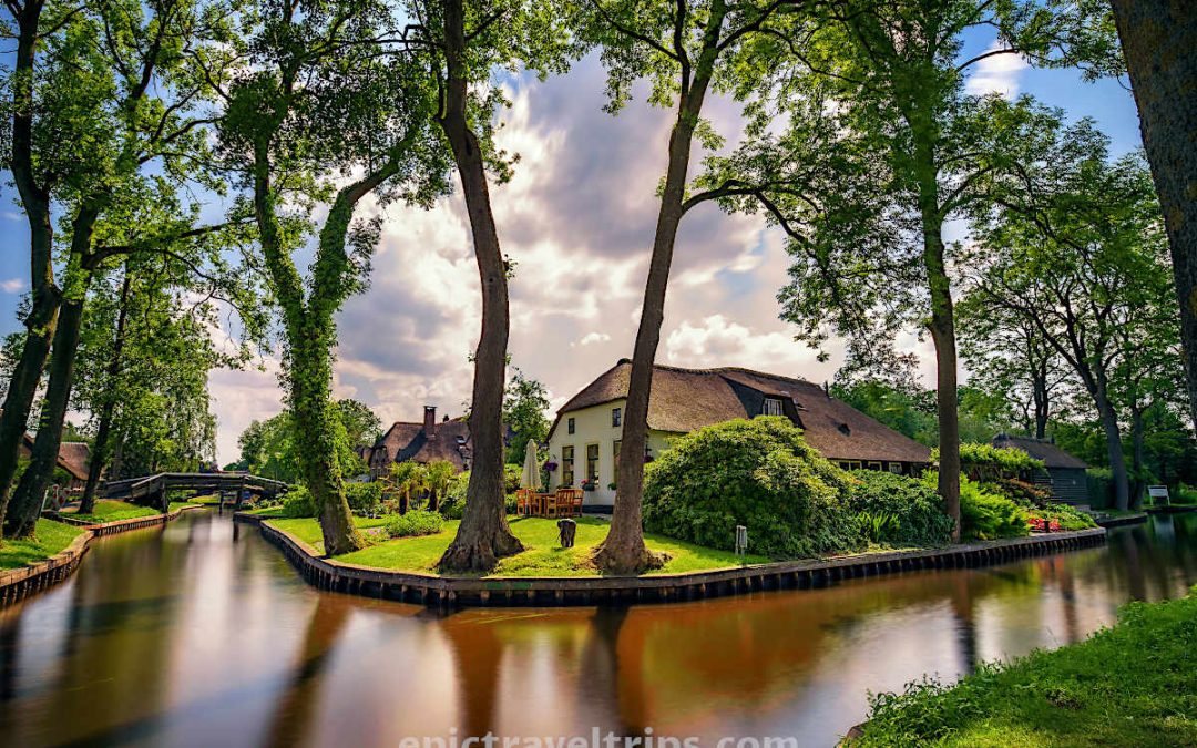
Giethoorn
Giethoorn village is not close to Fort Bourtange but was our next stop. The town is 130 km (80 mi) and 1 hour and 30 minutes drive from the fort. Besides, Giethoorn is a unique village that we have to mention it.
Giethoorn is a picturesque village due to its waterways, canals, and beautiful thatched farms built on small peat islands connected by over 170 small wooden bridges. We took a canal boat trip to see the sights.

De Haar Castle (Kasteel de Haar)
Please visit De Haar Castle (Kasteel de Haar in Dutch), provided you like visiting fortresses, castles, or palaces. The attraction is not close to Fort Bourtange but adds to the historical heritage of The Netherlands.
De Haar Castle is the largest castle in the Netherlands. Its location is outside Utrecht and a half-hour drive from Amsterdam. A leap of fate in the 19th century struck the lucky turn in the castle’s history and the beginning of rebuilding it into its past glory state. Its walls hide extravagant history and flamboyant castle owners’ lives, especially in the 1950s.

Fort Bourtange – Our Impressions
Fort Bourtange is a historical location of Dutch heritage. It was nice that we visited it. Yet, we admit that the best view of the fort has the birds from an aerial perspective. It is rare to see such a location but not as unique as our next destination Giethoorn “Dutch Venice” (Goat Horns).
We made a Google Map so you can follow our road trip and easily plan yours.
We wish you an epic trip!